 |
Cooperative Research Centre for Landscape
Environments and Mineral Exploration
Minerals Tertiary Education Council
Regolith Geology and Geochemistry
virtual field course
Course leaders:
Dr Ian Roach (MTEC Lecturer, CRC LEME, Australian National University)
Dr Steve Hill (CRC LEME, University of Adelaide)
Dr Mehrooz Aspandiar (CRC LEME, Curtin University of Technology)
Contents:
1. Course rationale, contents
and history
2. An introduction to South Gippsland
bedrock and regolith geological history
3. An introduction to SE Victorian
landscapes
4. Regolith-landform
map of Tidal River
5. Virtual field sites
6. Regolith Glossary
7. Acknowledgements and recommended reading
8. Powerpoint lectures
1. Course rationale, contents and history
This guide contains images and descriptions collected during CRC LEME's Regolith Geology and Geochemistry (RGG) short course, held since 2004 at Wilsons Promontory, Victoria. The contents are designed to give an overview of the regolith geology and landscape evolution of southeast Gippsland and Phillip Island. During this, numerous aspects of the region are discussed in terms of their regolith materials, how they evolved, why are they special and what they mean to our everyday lives. The RGG course is designed to introduce regolith geoscience and landscape evolution to 4th-year students, postgraduate students and professionals who have no experience of regolith. This guide is also intended for the use of its target audience and secondary and tertiary teachers who are keen to learn more about (or something about) regolith.
This site contains an overview of SE Victorian regolith geology and its recent tectonic history. The virtual field sites are arranged in order of their general position in the local stratigraphy, starting at the base and ending at the top of the stratigraphic column. Other features at each site are also shown and discussed in each section. Of course, some important features may have been left out, but we chose each site to highlight a specific feature of SE Victoria regolith geology; you can't visit every part of the coast between Wilsons Promontory and Phillip Island in a one-week course and have time to give lectures!
The course in the guise presented here commenced in 2004, but was offered before this by CRC LEME at the University of Melbourne. This course was offered annually, based at Wilsons Promontory, primarily within the Wilsons Promontory National Park (WPNP). The Principal course leaders, affiliations and years taught are:
- Dr Mehrooz Aspandiar (CRC LEME, Curtin University of Technology, Perth, 2004-2007)
- Dr Steve Hill (CRC LEME, University of Adelaide, 2004, 2005, 2007)
- Dr Ian Roach (MTEC Lecturer, CRC LEME, Australian National University, 2004-2007)
Other invited lecturers included:
- Mr Bernie Joyce (University of Melbourne, 2005)
- Dr Graham Heinson (CRC LEME and CERG, University of Adelaide, 2007)
Previous lecturers at the pre-2004 University of Melbourne course included:
- Dr Steve Hill (CRC LEME, Australian National University, University of Canberra)
- Mr Bernie Joyce (University of Melbourne)
- Professor Graham Taylor (CRC LEME, University of Canberra)
- Dr Andrew Kotsonis (University of Ballarat)
- Mr David Lawrie (Pasminco)
This course was offered as part of the Minerals Council of Australia's Minerals Tertiary Education Council (MTEC) initiative. The MTEC initiative commenced in 2001 as a partnership between the Minerals Council of Australia and universities or research organizations (including CRC LEME) involved in the earth sciences, mining engineering and metallurgy disciplines.
2. An introduction to South Gippsland bedrock and regolith geological history
The bedrock and regolith geology of South Gippsland includes rocks and structures that were formed during the Paleozoic, Mesozoic and Cenozoic Eras and regolith materials that were formed during the Mesozoic and Cenozoic Eras. The image below depicts the generalized geology of the South Gippsland region including Wilsons Promontory and Phillip Island.
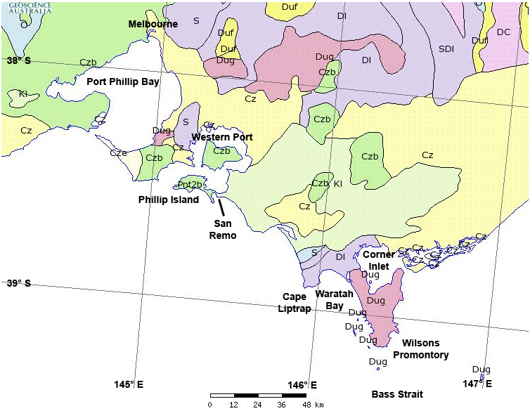
Bedrock geological units that are important to the regolith story of South Gippsland that occur in the map above include (in rough stratigraphic order):
- Cz, Cze - Cenozoic sediments
- Czb - Cenozoic basalts
- K1 - Cretaceous sedimentary rocks
- D - Devonian sedimentary rocks
- Dug - Devonian granites
- S - Silurian sedimentary rocks
What this map does not include are the Ordovician rocks that occur sporadically throughout the region. More detailed geological maps are included in the virtual field site descriptions (below).
This discussion will be limited largely to the geological history of the Melbourne Zone, which is defined roughly as the region between the Mt William Fault (western side of Port Phillip Bay) to the Governor Fault (striking northwest from Sale to the Victorian-NSW border) including Wilsons Promontory and Phillip Island.
Cambrian Period, Paleozoic Era
The oldest rocks in the Melbourne Zone are Cambrian greenstones. These are ophiolites (obducted ocean
crust basalts) and occur as thin fault slices amongst younger Paleozoic (Ordovician
to Devonian) rocks, but outcrops are too small to appear on the generalized geological
map above. These rocks occur at Waratah Bay, to the west of Wilsons Promontory,
as thin slices between Ordovician and Devonian rocks between the Waratah Fault and the Bell Point Fault. The faults
that juxtapose rocks of different ages against each other may themselves be much younger than Cambrian and may have moved throughout geological history since their earliest formation until recently. Cambrian greenstones also occur on the southern coast of Phillip Island at Kitty Miller Bay. You can learn more about the regolith
at Waratah Bay here.
Ordovician, Silurian and Early Devonian Periods, Paleozoic Era
At the start of this time, the Melbourne Zone was a trough (the Melbourne Trough) under deep water,
perhaps as much as 5 km. The Cambrian oceanic crust (now
seen as remnants of ophiolite in the greenstone belts) was gradually covered by marine sediments
ranging from coarse, well-rounded sands to fine black clays. The sands, silts and clays that dominate
the succession were deposited as a series of turbidite flows,
or flyschs, that were derived from the weathering and erosion of terrestrial
rocks to the west and south of the region. Volcanogenic (volcanoclastic) sediments are rare, implying that little igneous activity was occurring in the Melbourne Zone, but was occurring around its margins. During this time, water levels were gradually shallowing. You
can learn more about the regolith on the Devonian rocks at Red Bluff
here.
Middle to Late Devonian Period, Paleozoic Era
Most of the rocks comprising Wilsons Promontory
were added during the Middle to Late Devonian. Sedimentation in the area was now almost solely terrestrial after the Middle Devonian Tabberabberan Orogeny, in which the marine Melbourne Trough was compressed and uplifted to form a highland, probably also forming the thin slivers of ophiolite at this time. At Wilsons Promontory a series of granite
plutons intruded into the sediment pile during the Middle to Late Devonian, forming the Wilsons Promontory Batholith as a response to crustal thickening and heating during the latter stages of the Tabberabberan Orogeny. Granites were also intruding at Phillip Island (Cape Woolamai) at around
this time. In other parts of South Gippsland coeval volcanoclastic rocks
from the volcanoes that existed above the batholiths can also be found,
however, these appear to have been totally eroded away at Wilsons Promontory and Phillip Island.
During the Devonian, subaerially-exposed rocks were undergoing extensive weathering, including iron oxyhydroxide-fixation, and erosion. The Melbourne Zone was now subject to terrestrial weathering and erosion, forming regolith profiles at its surface. Much of the sedimentation in this part of Victoria, indeed in the entire Lachlan Fold Belt, was now as continental "red bed" facies - thick oxidised sandstones and mudstones in broad alluvial systems. Simple plants began to colonise the land during the Devonian, but most of the living action was occurring under water - the Devonian is known as the "time of fishes". The climate at this stage is believed to have been tropical to warm temperate, with this part of Victoria lying between 15 and 30 degrees south latitude. Slowly, between the Late Devonian and Permian, Australia (and the rest of Gondwanaland) drifted southwards towards the South Pole, eventually resulting in widespread glaciation in the Permian (although these sediments are not preserved at Wilsons Promontory or Phillip Island, if they existed at all). Follow these links to learn more about the regolith on the Devonian rocks at Mt Oberon, Little Oberon Bay, Tidal River and Red Bluff.
Cretaceous Period, Mesozoic Era
In the Cretaceous, the land (part of Gondwanaland) was now heavily colonised by land plants, dinosaurs, insects and small mammals after the Carboniferous "life explosion". During
the Mid- to Late Cretaceous the bulk of Gondwanaland was finally rifted apart, creating
the continents of Australia and Antarctica and the New Zealand South Island. This process had begun in western Gondwanaland with the separation of India from Western Australia at about 200 Ma. This gradual "unzipping" finally reached southern Australia at about 100 Ma and finished at the Coral Sea in northeastern Australia at about 60 Ma. The presence of the E-W striking Ballan Graben near Melbourne indicates that the initial N-S stretching of the continent may have commenced as early as the Late Permian. This process also included the rifting-apart of Antarctica, Africa and South America.
Large Jurassic to Early Cretaceous sedimentary basins formed in the widening rift including the Otway Basin to the west of Wilsons Promontory, the Bass Basin to the south and the Gippsland Basin to the east, as southern Victoria and Tasmania were stretched southwards by the continental rifting process. Accompanying the rifting, composite volcanoes were springing up within the basins and these contributed large amounts of quartzose and feldspathic volcanoclastic sediment to the new basins in terrestrial depositional settings, together with the other terrestrial sediments being stripped from the continental landmass as river base levels were drastically altered.
At about the same time as Australia, Antarctica and New Zealand were rifting apart, the Eastern Highlands (Victorian Alps) were rising, perhaps in isostatic response to the rifting process and the addition of large amounts of basaltic magma to the base of the local crust. This process caused the large-scale dissection of the Mesozoic landscape, believed to have been a relatively flat peneplain, although this is somewhat controversial and many theories exist to describe the actual form of the Mesozoic landscape of southeastern Australia. At this stage the landscape was certainly being divided up into large scale fault blocks, the uplifted ones being weathered and eroded and the downthrown ones receiving sediment. Continental rifting along the Otway-Bass-Gippsland Basin axis failed but was successful around the southern margin of Tasmania, ultimately resulting in the final separation of Australia from Antarctica. Follow these links to learn more about regolith on Cretaceous rocks at Foster Lookout and San Remo.
Tertiary-Recent Period, Cenozoic Era
Once the rifting between Australia and Antarctica had advanced sufficiently, global weather patterns changed causing temperatures to fall because the circum-polar current became established in the Southern Ocean, preventing warm currents from the tropics from heating the lower latitudes.
This meant that the South Pole started to experience long-term freezing temperatures. Australia began a slow northward tectonic drift that brought the continent into new climatic regimes, resulting in an overall climate change in SE Victoria from near-freezing to temperate, and resulted in an overall drying-off of the landscape in perhaps the last 15 My. This climate change is noted in paleomagnetic ages of iron-rich mottles in saprolite from central NSW (Pillans 2005).
During the Tertiary, a succession of basaltic lavas erupted along the eastern highlands commencing at about 60 Ma, forming the Victorian "Older Volcanics" (a term which has now fallen out of favour). Lavas continued to erupt sporadically until fairly recently, with the latest eruption on the Australian mainland occurring about 4,500 years ago at Mt Schank in southern South Australia. Basalts filled the landscape, preserving earlier landscapes and materials and, in some cases, joining smaller landmasses together. This appears to have occurred at Phillip Island, which would have been a series of small granitic domes (one still visible at Cape Woolamai) connected by shallow water passages or brackish swamps when basalts first erupted there about 45-50 million years ago. Basalts start to weather almost immediately after eruption and thick clay-rich soil mantles developed on the tops of flows within several thousand years after eruption. Many of these are still visible where they are preserved by over-topping basalt flows or sediments. Follow these links to learn more about the regolith on Tertiary-Recent rocks and regolith materials at Flynn's Beach, San Remo, Red Bluff, Little Oberon Bay, Squeaky Beach and Pyramid Rock.
Pleistocene-Holocene glaciation, Cenozoic Era
During the last 150,000-200,000 years the Earth has been undergoing a series of large scale glaciations, which have dramatically affected the geology and landscapes of SE Victoria. During the glacial maxima, where large amounts of water were stored in the ice caps, global sea levels may have been as much as 100 m lower than present day ones. In the Wilsons Promontory area the sea shore was many kilometres away from the present day shoreline and large amounts of carbonate sand were exposed. The climate during the glacial maxima was cold to cool and rainfall was low, resulting in very dry conditions. Little vegetation would have tolerated these conditions and wind erosion would have been common. Carbonate sand was blown from the wide plain of the newly-exposed continental shelf onto Wilsons Promontory where it is now preserved as buff-coloured carbonate-rich aeolianite dunes at Darby Beach. During the inter-glacials, where the climate returned to conditions more like the present day, carbonate in these dunes has been partially dissolved and re-precipitated in root tubules and along bedding planes, forming a rhizomorphic calcrete, or regolith carbonate accumulation. Prominent paleosols are also present in the dune sequences, filling the ancient dune swales.
More recently, during perhaps the last 10,000 years, modern white quartz sand dunes have over-topped the carbonate dunes at Darby Beach, preserving aboriginal middens. Follow these links to learn more about the Pleistocene-Holocene regolith materials at Darby Beach.
3. An introduction to SE Victorian landscapes
Southeastern Victoria, including the area around Melbourne and South Gippsland, is a fascinating part of Australia because the landscapes have been heavily modified by recent tectonic (or neotectonic) activity. This activity has divided the land up into a series of fault blocks, creating uplands and sunklands (horsts and grabens) that control the landscape evolution of this region.
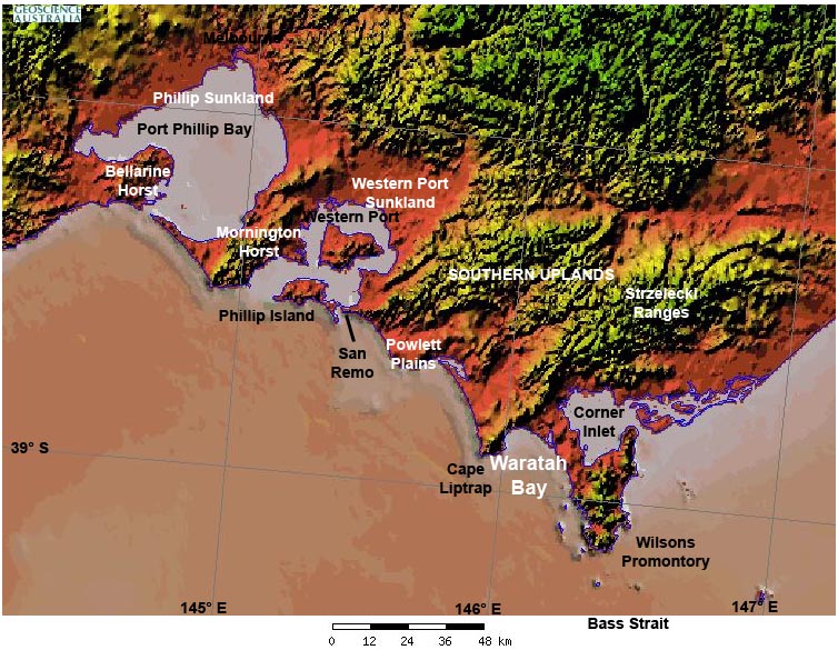
The image above is a generalized map of SE Victorian landscapes using a digital elevation model as a backdrop. The major geomorphic features are labeled, however, these can be further subdivided (see image below), based on the geomorphic classification of Jenkin (1976).
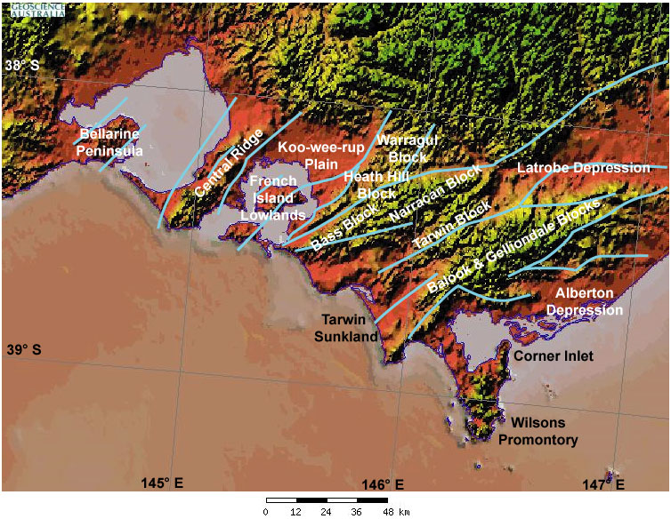
The map above divides South Gippsland into geomorphic regions, mostly uplifted fault blocks and sunken lowlands (or sunklands). These are separated by a series of Paleozoic and post-Paleozoic faults (shown in blue) that have been reactivated by stress in the Australian crust. Movement along faults can be dated by examining the age of deposits either side to determine relative age, or by isotopic dating methods (e.g., U-series, Ar-Ar, 14C) to determine absolute age. Many of the faults are known to have been neotectonically active (i.e., within the last 3 million years), because they offset Cenozoic deposits like brown coal seams and basalt lava flows that can be dated using pollen and isotopes, respectively.
4. Regolith-landform map of Tidal River
The regolith-landform map of Tidal River was developed by Dr Steven Hill in 2004 from earlier data from his University of Melbourne Honours project of 1992 (The Granitic Regolith and Associated Geomorphology of Wilsons Promontory, Victoria, Australia. BSc (Hons), School of Earth Sciences, University of Melbourne). A regolith-landform map describes landforms and associated surface regolith materials and other features that occur within them. The maps are developed principally by mapping landforms, but other considerations such as regolith mineralogy, vegetation and geohazards are also taken into consideration when drawing lines on the map.
The version present here is interactive, with each polygon hyperlinked to a database describing regolith materials, landform(s), dominant vegetation, geohazards, remote sensing attributes and "other attributes" of each polygon (also called a regolith-landform unit - RLU). Each site description also contains a photograph that characterizes the regolith-landform features of the site, setting it apart from other RLUs.
Click here to see the interactive
Tidal River regolith-landforms map.
(Opens in new window, best at 800x600 or larger)
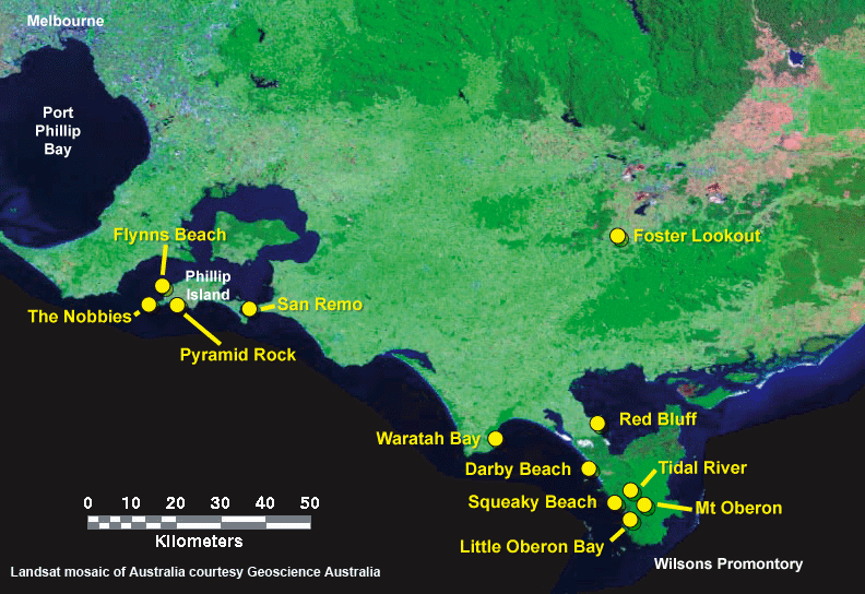
5. Virtual field sites
This section contains photographs and descriptions of field sites used during the delivery of the Regolith Geology and Geochemistry course over 4 years. Normally there is not time to visit all of the sites, deliver all of the lecture material and complete the assessment material within one week, but here you can do all of this at your leisure!
The sites below are listed in approximate order of their position in the Wilsons Promontory-Phillip Island stratigraphy, from lowest to highest, which is important to learn when building up a landscape evolution history of a region. Sites also contain descriptions of ancient and modern regolith processes that have occurred, or are still occurring, at each. The annotations are necessarily brief but are designed to capture the dominant material, process or significance of each site. Use the image map below if you wish - the names are linked to each site.
|
|
See the Virtual Field Sites in Google Earth: click HERE. You must have Google Earth loaded on your computer. Macintosh users may need to download the .kml file and open it separately. |
|
6. Regolith Glossary
Click here to open a searchable PDF version of The Regolith Glossary, edited by R.A. Eggleton (© CRC LEME 2001). You will need the Adobe Acrobat reader installed on your computer to read this.
7. Acknowledgements and recommended reading
We gratefully acknowledge the following organizations or people for data and/or discussions since 2004:
- Geoscience Australia
- Department of Natural Resources and Energy Victoria
- New South Wales Department of Primary Industries
- Mr Bernie Joyce
- Professor Graham Taylor
Recommended reading
- Ashton, D.H. & Webb, R.N., 1977. The ecology of granite outcrops at Wilsons Promontory, Victoria. Australian Journal of Ecology, 2, 269-296.
- Birch, W.D., 1998. Minerals on Wilsons Promontory. The Victorian Naturalist, 306-309.
- Bolger, P.F., 1991. Lithofacies variations as a consequence of Late Cainozoic tectonic and palaeoclimatic events in the onshore Gippsland Basin. In: Williams, M.A.J., DeDeckker, P., & Kershaw, A.P. (eds). The Cainozoic in Australia: a re-appraisal of the evidence, pp.158-180. Geological Society of Australia Special Publication 18.
- Chesterfield, E.A., 1998. The vegetation of Wilsons Promontory National park. The Victorian Naturalist, 115, 310-321.
- Conn, B.J., 1993. Natural regions and vegetation of Victoria. In Foreman, D.B. & Walsh, N.G. (eds) Flora of Victoria. Inkata Press, 79-158.
- Coutts, P.J.F., 1967. The archaeology of Wilsons Promontory. Australian Institute of Aboriginal Studies, Monograph 28.
- Dhu T., Heinson G. & Joseph J. 2004. Viewing the regolith through different eyes: a new way of interpreting resistivity data. In: Roach I.C. ed. Regolith 2004. CRC LEME, pp. 71-75. Also available at: http://crcleme.org.au/Pubs/Monographs/regolith2004/Dhu_et_al.pdf.
- Dumitru, T.A., Hill, K.C., Coyle, D.A. et al., 1991. Fission track thermochronology: application to continental rifting in south-eastern Australia. The APEA Journal, 31, 131-142.
- Douglas, J.G., 1988. The Gippsland Basin. In Douglas, J.G & Ferguson, J.A. (eds), Geology of Victoria. Geological Society of Australia, 228-233.
- Duddy, I.R. & Green, P.F., 1992. Tectonic Development of the Gippsland Basin and Environs: Identification of Key Episodes Using Apatite Fission Track Analysis (AFTA). Gippsland Basin Symposium, 111-120.
- Fitzpatrick A.& Clarke J.D.A. 2004. The potential of geophysics to map salt water intrusion in the Burdekin Delta. In: Roach I.C. ed. Regolith 2004. CRC LEME, pp. 88-92. Also available at: http://crcleme.org.au/Pubs/Monographs/regolith2004/Fitzpatrick&Clarke.pdf.
- Fitzpatrick A. Clarke J.D.A. & Lawrie K. 2004. Multidisciplinary approach to salinity management in the Lower Balonne, southern Queensland. In: Roach I.C. ed. Regolith 2004. CRC LEME, pp. 93-96. Also available at: http://crcleme.org.au/Pubs/Monographs/regolith2004/Fitzpatrick_et_al.pdf.
- Fitzpatrick R.W., Baker A.K.M., Raven M., Rogers S., Degens B., George R. and Kirby J. 2005. Mineralogy, biogeochemistry, hydro-pedology and risk of sediments, salt efflorescences and soils in open drains in the wheatbelt of Western Australia. In: Roach I.C. ed. Regolith 2005 - Ten Years of CRC LEME. CRC LEME, pp. 97-101. Also available at: http://crcleme.org.au/Pubs/Monographs/regolith2005/Fitzpatrick_et_al.pdf.
- Gray D.R. & Foster D.A. 2004. Tectonic evolution of the Lachlan Orogen, southeast Australia: historical review, data synthesis and modern perspectives. Australian Journal of Earth Sciences 51(6), 773-817.
- Hatch M. Heinson G. & Munday T. 2005. Temporal monitoring of floodplain hydrogeology using electrical and electromagnetic geophysical methods. In: Roach I.C. ed. Regolith 2005 - Ten Years of CRC LEME. CRC LEME, pp. 129-133. Also available at: http://crcleme.org.au/Pubs/Monographs/regolith2005/Hatch_et_al.pdf.
- Heinson G., Hatch M., Dhu T., Kim S., Gibbins L., Neroni R., Fily G. & Duval G. 2006. Developments in hydrogeophysical research. In: Fitzpatrick R.W. & Shand P. eds. Regolith 2006 - Consolidation and Dispersion of Ideas. CRC LEME, pp. 136-138. Also available at: http://crcleme.org.au/Pubs/Monographs/regolith2006/Heinson_G.pdf.
- Hill, S.M., 1992. The Granitic Regolith and Associated Geomorphology of Wilsons Promontory, Victoria, Australia. BSc. (Hons) thesis, The University of Melbourne, unpublished.
- Hill, S.M., 1994. Some granite landforms of Wilsons Promontory, Victoria. The Victorian Naturalist, 111, 184-190.
- Hill, S.M., 1996. The differential weathering of granitic rocks in Victoria, Australia. AGSO Journal of Australian Geology & Geophysics, 16, 271-276.
- Hill, S.M. 2005. Wilsons Promontory, Victoria. In: Anand R.R. & de Broekert P. eds. Regolith landscape evolution across Australia. CRC LEME, Perth, pp. 258-262. Also available at: http://crcleme.org.au/RegLandEvol/WilsonsPromontory.PDF.
- Hill, S.M., & Bowler, J.M., 1995. Linear dunes at Wilsons Promontory and south-east Gippsland, Victoria: relict landforms from periods of past aridity. Proceedings of the Royal Society of Victoria, 107, 73-81.
- Hill, S.M., & Joyce, E.B., 1995a. Granitic regolith and landscape evolution of Wilsons Promontory, Victoria. Proceedings of the Royal Society of Victoria, 107, 1-10.
- Hill, S.M., & Joyce, E.B., 1995b. The mapping of granitic regolith and landform features at Wilsons Promontory, Victoria. In: McQueen, K.G. & Craig, M.A. (eds), Developments and New Approaches in Regolith Mapping, Centre for Australian Regolith Studies Occasional Publication, 3, 31-41.
- Hill, S.M., Ollier, C.D. & Joyce, E.B., 1995. Mesozoic deep weathering and erosion: an example from Wilsons Promontory, Victoria. Zeitschrift fur Geomorphologie, 39, 331-339.
- Hill, S.M., 1999. Mesozoic regolith and palaeolandscape features in southeastern Australia: significance for interpretations of denudation and highland evolution. Australian Journal of Earth Sciences, 46, 217-232.
- Hills, E.S., 1975. Physiography of Victoria. Whitcomb & Tombs, 373 pp.
- Hocking, J.B., 1988. Gippsland basin. In Douglas, J.G. & Ferguson, J.A. (eds), Geology of Victoria, Geological Society of Australia, 322-347.
- Hope, G.S., 1974. The vegetation history from 8000 B.P. to present of Wilsons Promontory, Victoria, Australia. New Phytologist, 73, 1035-1053.
- Hulme K. & S.M. Hill 2003. River red gums as a biogeochemical sampling medium in mineral exploration and environmental chemistry programs in the Curnamona Craton and adjacent regions of NSW and SA. In: Roach I.C. ed. Advances in Regolith. CRC LEME, pp. 205-210. Also available at: http://crcleme.org.au/Pubs/Advancesinregolith/Hulme_Hill_SM.pdf.
- Hulme K.A. and Hill S.M. 2004. Seasonal element variations of Eucalyptus camaldulensis biogeochemistry and implications for mineral exploration: an example from Teilta, Curnamona Province, western NSW. In: Roach I.C. ed. Regolith 2004. CRC LEME, pp. 151-156. Also available at: http://crcleme.org.au/Pubs/Monographs/regolith2004/Hulme&Hill.pdf.
- Hulme K.A. & Hill S.M. 2005. River red gum biogeochemistry associations with substrate: bedrock penetrators or stream sediment amalgamators? In: Roach I.C. ed. Regolith 2005 - Ten Years of CRC LEME. CRC LEME, pp. 146-151. Also available at: http://crcleme.org.au/Pubs/Monographs/regolith2005/Hulme_&_Hill.pdf.
- Hulme K. & Hill S. 2005. Mineralisation discovery through transported cover using river red gums (Eucalyptus camaldulensis). In: CRC LEME Mineral Exploration Seminar Abstracts, Perth WA, 25 May 2005. Also available at: http://crcleme.org.au/NewsEvents/Events/Minex%20Seminar%20May%2005/Abstract_Volume_Minex%20May05.pdf.
- Jenkin, J.J., 1968. The geomorphology and upper Cainozoic geology of south-east Gippsland, Victoria. Geological Survey of Victoria Memoir, 27, 147pp.
- Jenkin J.J. 1976. Chapter 10 Geomorphology. In: Douglas J.G. and Ferguson J.A. eds. Geology of Victoria. Geological Soceity of Australia Special Publication No. 5. Note: the geomorphology chapter - Chapter 18 - in Birch (2003) Geology of Victoria (Geol Soc Aust Spec Pub 23) has been substantially rewritten and much of Jenkin's work, including the geomorphological map, has been left out - you will need to read the original publication.
- Joyce, E. B. 1999. A new regolith landform map of the Western Victorian volcanic plains, Victoria, Australia, In: Taylor G & Pain C. eds. Regolith '98, Australian Regolith & Mineral Exploration, New Approaches to an Old Continent, Proceedings. 3rd Australian Regolith Conference, Kalgoorlie, 2-9 May 1998, CRC LEME, Perth, pp.117-126.
- Joyce, E. B. 2005. Western Volcanic Plains, Victoria. In: Anand R.R. & de Broekert P. eds. Regolith landscape evolution across Australia. CRC LEME, Perth, pp. 253-257. Also available at: http://crcleme.org.au/RegLandEvol/WVicPlains.pdf.
- Joyce, E.B., Webb, J.A., Dalhaus, P.G., Grimes, K.G., Hill, S.M., Kotsonis, A., Martin, J., Mitchell, M.M., Neilson, J.L., Orr, M.L., Peterson, J.A., Rosengren, N.J., Rowan, J.N., Rowe, R.K., Sargeant, I., Stone, T., Smith, B.L. & White, S., 2003. Geomorphology: the evolution of Victorian landscapes. In: Birch W.D. ed. Geology of Victoria, pp. 533-561. Geological Society of Australia Special Publication 23. Geological Society of Australia (Victoria Division).
- Kim S., Heinson G. & Joseph J. 2006. Field measurements of electrokinetic potential during a pumping test. In: Fitzpatrick R.W. & Shand P. eds. Regolith 2006 - Consolidation and Dispersion of Ideas. CRC LEME, pp. 196-201. Also available at: http://crcleme.org.au/Pubs/Monographs/regolith2006/Kim_S.pdf.
- Kotsonis, A. & Joyce, B., 2003. Regolith mapping at Bendigo, and its relationship to gold in central Victoria, Australia. In: Roach I.C. ed. Advances in Regolith, pp. 239-243. CRC LEME.
- Kotsonis, A. & Joyce, E. B. 2003. The regolith of the Bendigo 1:100 000 map area. Victorian Initiative for Minerals and Petroleum Report 77, Department of Primary Industries, 62 pp. + map.
- Ladd, P.G., 1979. A Holocene vegetation record from the eastern side of Wilsons Promontory, Victoria. New Phytologist, 82, 265-276.
- Oyston, B., 1988. The geology and Cainozoic evolution of the Yanakie Isthmus, Victoria. Unpublished, BSc. (Hons) thesis, Department of Geology, The University of Melbourne, 65 pp.
- Parsons, R.F., 1966. The soils and vegetation at Tidal River, Wilsons Promontory. Proceedings of the Royal Society of Victoria, 98, 319-354.
- Pillans, B. 2005. Geochronology of the Australian regolith. In: Anand RR and de Broekert P. eds. Regolith landscape evolution cross Australia. CRC LEME, Perth, pp. 41-51. Also available at: http://crcleme.org.au/RegLandEvol/Geochron_of_%20Aust_Regolith.pdf.
- Richards, J.R. & Singleton, O.P., 1981. Palaeozoic Victoria, Australia: Igneous rocks, ages and their interpretation. Journal of the Geological Society of Australia, 28, 395-421.
- Roach I.C. 2004. Results of a preliminary biogeochemical survey of the Wyoming Au deposit, Tomingley, NSW. In: Roach I.C. ed. Regolith 2004. CRC LEME, pp. 307-310. Also available at: http://crcleme.org.au/Pubs/Monographs/regolith2004/Roach.pdf.
- Roach I.C. 2006. Tomingley project, central western NSW, 1: regolith-landform mapping techniques and implications for landscape evolution. In: Fitzpatrick R.W. & Shand P. eds. Regolith 2006 - Consolidation and Dispersion of Ideas. CRC LEME, pp. Also available at: http://crcleme.org.au/Pubs/Monographs/regolith2006/Roach_I.pdf.
- Roach I.C. 2006. Tomingley project, central western NSW 2: regolith-landforms of the Tomingley area. In: Fitzpatrick R.W. & Shand P. eds. Regolith 2006 - Consolidation and Dispersion of Ideas. CRC LEME, pp. Also available at: http://crcleme.org.au/Pubs/Monographs/regolith2006/Roach_I_2.pdf.
- Roach I.C. & Walker S.D.2005. Biogeochemical expression of gold in native tree leaves at Wyoming and Tomingley, NSW. In: Roach I.C. ed. Regolith 2005 - Ten Years of CRC LEME. CRC LEME, pp. 277-282. Also available at: http://crcleme.org.au/Pubs/Monographs/regolith2005/Roach_&_Walker.pdf.
- Sargeant, I., Imhof, M., Lourey, R., Martin, J., Nink, R., de Plater, K., Rampant, P., & Thompson, S., 1995. Major Agricultural Soils of Southwest Gippsland: companion notes for Australian Society of Soil Science Field Day. 59 pp plus appendices.
- Shand P., James-Smith J., Hodgkin T., Fitzpatrick R., McClure S., Raven M., Love A., Stadter M. & Hill T. 2006. Al(OH)3 clogging in salt interception scheme boreholes at Bookpurnong, Murray Basin: the role of pyrite and hydroxy-sulfate minerals in ancient coastal acid sulfate sediments. In: Fitzpatrick R.W. & Shand P. eds. Regolith 2006 - Consolidation and Dispersion of Ideas. CRC LEME, pp. 307-312. Also available at: http://crcleme.org.au/Pubs/Monographs/regolith2006/Shand_P.pdf.
- Spencer-Jones, D., 1955. Geology of the Toora Tin-field. Geological Survey of Victoria Bulletin, 54, 58 pp.
- Tan K.P., Munday T.J., Apps H.E.J. & Halas L., 2006. Interpreting the electrical conductivity response of regolith materials in various geomorphic settings across Australia. In: Fitzpatrick R.W. & Shand P. eds. Regolith 2006 - Consolidation and Dispersion of Ideas. CRC LEME, pp. 339-342. Also available at: http://crcleme.org.au/Pubs/Monographs/regolith2006/Tan_K.pdf.
- Tuddenham, W.G., 1970. The coastal geomorphology of Wilsons Promontory Victoria: implications concerning Quaternary sedimentation around the shores of Bass Strait. Unpublished MSc. Thesis, Department of Geography, Sydney University.
- Wallis, G.L., 1981. The geology of the Wilsons Promontory Batholith, Victoria: a study of the composition, emplacement and structure of an S-type granitoid. Unpublished MSc. Thesis, Department of Geology, Monash University.
- Wallis, G.L., 1988. Wilsons Promontory. In: Clark, I. & Cook, B.ed., Victorian Geology Excursion Guide. pp.353-372. Australian Academy of Science.
- Wallis, G.L., 1998. The geology of Wilsons Promontory. The Victorian Naturalist, 115, 300-309.
- Wellman P. 1979. On the Cainozoic uplift of the southeastern Highlands. Journal of the Geological Society of Australia 26, 1-9.
- Wellman P. 1980. Mechanism of uplift of the eastern highlands, from K-Ar dating, regional gravity, and repeat geodetic measurements. In: Truswell E.M. & Abell R.S. eds. The Cainozoic Evolution of Continental Southeast Australia. Record 1980/67. Bureau of Mineral Resources, Geology and Geophysics, Canberra, 73-74.
- Wellman P. 1987. Eastern Highlands of Australia: their uplift and erosion. Bureau of Mineral Resources Journal of Australian Geology and Geophysics 10, 277-286.
- Veevers J.J. 1987. Stratigraphic constraints on the history of the Eastern highlands. CSIRO Technical Memorandum 87(2), 3-7.
General reading:
- W.D. Birch ed. 2003. Geology of Victoria. Geological Society of Australia Special Publication No. 23.
- Eggleton R.A. 2002. The Regolith Glossary. CRC LEME, Perth.
- R.W. Johnson ed. 1989. Intraplate Volcanism in Eastern Australia and New Zealand. Cambridge University Press, Melbourne.
- D. Meagher and M. Kohout 2001. A field guide to Wilsons Promontory. Oxford University Press, South Melbourne, Victoria.
- M.E. White 1986. The greening of Gondwana. Reed, Chatswood NSW.
- M.E. White 1994. After the Greening - The Browning of Australia. Kangaroo Press, Kenthurst NSW.
More general and specific regolith abstracts and reports are available for free download at:
http://crcleme.org.au/
8. Powerpoint lectures (open into PowerPoint)
- Regolith: what's all that about? - Ian Roach (9 Mb)
- Landscape Evolution - Steve Hill (49.3 Mb)
- Weathering mechanisms and products - Mehrooz Aspandiar (6 Mb)
- Regolith geochemistry and mineralogy - Mehrooz Aspandiar (5.3 Mb)
- Regolith minerals: types, nature and significance - Mehrooz Aspandiar (2.4 Mb)
- Regolith profiles: nomenclature of the regolith - Mehrooz Aspandiar (6.9 Mb)
- Applications of regolith geoscience - Ian Roach (143.6 Mb)
- Colluvial regolith - Steve Hill (23.8 Mb)
- Regolith geophysics: outside the square - Graham Heinson (24.1 Mb)
Written by Dr Ian Roach, MTEC Lecturer and CRC LEME Education and Training Program Leader, February 13, 2008