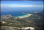
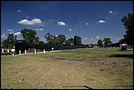
 tr1.jpg | Let's have a look at the general landscape and regolith materials around the Tidal River campground at Wilsons Promontory National Park. It's always nice to stroll around and look at things. This image is taken from the top of Mt Oberon looking north over Little Oberon (left), the Tidal River camping ground and Norman Beach, Tidal Overlook and Pillar Point (the next headland to the north), Squeaky Beach and Whiskey Bay. The significance of this landscape has already been mentioned at Mt Oberon. However, let's look a little closer at some of the materials and issues in the immediate vicinity of the campground. |
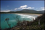 tr2.jpg | Here's a view looking towards Norman Beach, Tidal River and Mt Bishop. Notice the wide, shallow beach, perfect for swimming, and the dune barrier behind it. As explained earlier at Mt Oberon, the dune barrier holds the estuarine sediments of Tidal River back from the ocean. |
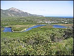 tr3.jpg | Behind the dune barrier we find the estuary of Tidal River, seen here looking southwest from Tidal Overlook. Take careful note of the type of vegetation occupying the various niches in this image. Do you see the swamp grasses (Juncus maritimus) in the swamps around the river? Then there's the Melaleuca thicket occupying the swampy sediments around that, the Leptospermum thicket occupying the sand dunes and finally the Xanthorrhea grass trees occupying the sand plains in the foreground. |
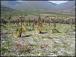
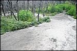 tr4.jpg | Here's an example of what the barrier dunes look like close up. Notice the stream channel running diagonally across the path? The sediments are loose, gray quartz sands with a little gravel mixed through from the stream, which drains from the flanks of Mt Oberon. Notice also the burnt Melaleuca shrubs and the green regrowth around their bases. What kind of land management issues are present here? The soil is very easily erodable, especially after a bushfire, and tends to be very nutrient-poor. To manage this land properly, care needs to be taken to conduct low-intensity controlled burns to reduce woody weeds and to encourage regrowth of ground cover to hold the loose soil together. |
 tr5.jpg | The grass tree or Xanthorrhea is also adapted to having dry feet and growing in nutrient-poor soils. It grows freely in an ecological niche on the sandplains at The Prom. Apart from needing the odd bushfire to clean up the vegetation and remove woody weeds, the ecological niches at Wilsons Promontory are still largely intact. This means that there is still a strong relationship between regolith-landforms and the vegetation growing on them, meaning that vegetation can be used as a surrogate when mapping regolith-landforms in this area. |
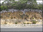 tr6.jpg | What's underneath the sand plains at Tidal River? Here's a cross section in a road cutting. The material is aeolian sand, blown into place by winds during the cold, arid glacial periods that have shaped much of the regolith geology of The Prom. Look closely and you'll see that the sand has now been turned into a soil by the process of pedogenesis. Notice the top part of the section is bleached white, and the bottom part is buff-yellow coloured? Can you suppose what's happening here, based on your knowledge of regolith materials from other areas? No? The soil profile here has a distinct A- and B-horizon. The A-horizon on top is bleached white because it has been leached of most minerals except quartz by elluviation - the process of removing soil minerals downwards through a soil profile. The B-horizon is illuviated; it has received and is concentrating materials removed from the A-horizon. There is a contrast in soil textures between the A- and B-horizons. The A-horizon is sandy and very loose. The B-Horizon is somewhat crumbly, but contains small loose nodules and some clays. This is regarded as a texture-contrast soil or a podsol. Depending on where you are in the world, a soil can take anywhere between 1000 and 10,000 years to form. The soils at Wilsons Promontory probably took many thousands of years to form too. |
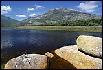 tr7.jpg | This view is looking south across Tidal River to Mt Oberon from the footbridge leading to Tidal Overlook. Note the colour of the water - it's tea-brown. What gives the water this colour? Tannin. Tidal River drains a series of swamps and alluvial plains that are thickly vegetated by dry sclerophyll forest, small pockets of wet sclerophyll rainforest, melaleuca thickets and sedge swamps. Organic matter from these has formed thick peat deposits which are slowly decomposing to form tannin. Water draining through the organic material carries the tannin - full of weak humic (organic) acids - to the Bass Strait through Tidal River. Tannin and it's associated humic acids are important agents for rock weathering. |
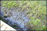 tr8.jpg | Whoa! Ferrihydrite here too! This means that the same redox processes are occurring here as we encountered at Red Bluff and Flynn's Beach. The swampy organic-rich sediments held back by the coastal dune barrier at Tidal River are also Potential Acid Sulfate Soils (PASS). Interfering with them by altering the water table will result in sudden acid discharge and the consequent fish-kills and other environmental damage that go with it. Estuarine environments need to be handled very carefully in order to avoid these problems. |
 zzz.jpg | Finally, here's a picture showing the evidence for the most recent marine incursion in the Murray Basin. |