 lob1.jpg |
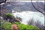
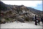
Welcome to Little Oberon Bay, Wilsons Promontory National Park. Little Oberon Bay lies to the south of Norman Beach and the Tidal River camping ground and is nestled south of the foot of Little Oberon and Mount Oberon to the west. Little Oberon Bay contains a range of easily accessible regolith materials and landforms that add to the total regolith experience of the Wilsons Promontory National Park. Little Oberon Bay is a great place to learn about colluvial regolith processes including debris flows (included as processes amongst the gamut of "landslides"). The following images are of debris flow deposits on the slopes of Mount Oberon in Little Oberon Bay. What's colluvium? It is material composed generally of angular to subangular rock and mineral fragments that has accumulated in the lower parts of slopes that has been transported there by gravity, soil creep, sheet flow, rain wash, mass flow or solifluction. |
|||||||||||||||||||||
 lob2.jpg |
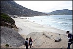
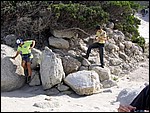
Walk down into Little Oberon Bay and you'll immediately be struck by how rocky the hillside and shoreline is. In this photo, Mount Oberon lies to the left and Little Oberon behind you. The narrow beach has prominent low cliffs and a major drainage channel that takes rainfall off the western slopes of Mt Oberon. The beach deposits are well sorted quartz sands, however, as you'll see, the deposits in the cliffs behind the beach are very different! | |||||||||||||||||||||
 lob3.jpg |
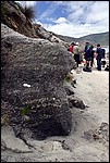
There are a range of materials present within the cliff faces and shoreline. Here's an exposure of poorly sorted angular silt, sand and gravel (sand- to pebble-size particles) composed of quartz and granite lithic sediment. Notice the centimetre scale bar on the exposure. The sediments are also weakly stratified (bedded). When describing regolith materials we use the Wentworth size classification scheme, which attributes grain size ranges to particular names:
The examples below illustrate the range of colluvium at Little Oberon Bay from the smallest to largest grain size materials. | |||||||||||||||||||||
 lob4.jpg |
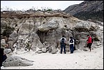
Here's another example of poorly sorted sediments. In this case, very poorly sorted (notice the boulders in the cliff face!). The sediments are debris flow deposits, which are classified as colluvial regolith. Colluvium may be deposited by gravity (landslides), as debris flows in high- to moderate-relief landforms including high-relief colluvial fans along rangefronts and mountainsides and as moderate-relief sheetwash fans in areas with more subdued relief. The important thing to remember with colluvium is, even though it might be deposited by gravity or water (so how is it different to alluvium you ask?) it's always near to its source and is generally poorly sorted with angular fragments (although there are always exceptions to generalizations in geology!). | |||||||||||||||||||||
 lob5.jpg |
In this example the sediments have a larger grain size and are extremely poorly sorted. You'll notice that some boulders have appeared in the cross-section, however, the deposits are characterized by matrix-supported clasts (large clasts suspended in smaller particles). Debris flows occur in areas of high relief on mountain or hill slopes and have been described by the USGS as being "soupy". They feature a dense mixture of poorly sorted materials and can move downslope slowly as slumps, or more vigorously as mudflows, depending on the amount of water they contain. Densities of debris flows vary depending on the types and grain sizes of materials being carried and amount of contained water, but can be as high as 2200 kgm-3, measured in volcanoclastic debris flows at La Fossa volcano on the island of Vulcano, in Italy (Ferrucia et al. 2005). Considering the typical density of granite (2700-2800 kgm-3), debris flows are almost as dense as the materials they contain. Large blocks of rock are rafted within debris flows (almost "floated") and are deposited in a chaotic assembly once the flows comes to rest. Debris flows represent a considerable geohazard in areas where there is high relief, lots of rainfall or snow accumulation or areas that are tectonically active (like volcanoes and mountain ranges). They are capable of scouring out channels and, because of their density and erosive capabilities, can undermine and physically lift and remove infrastructure like road and rail bridges, weirs and dams. | |||||||||||||||||||||
 lob6.jpg |
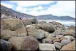
In this example, we're looking at a clast-supported debris flow deposit on the beach. This deposit has very little fine material, consisting mostly of granite boulders and cobbles, and would have moved quite slowly down hill to its resting place. | |||||||||||||||||||||
 lob7.jpg |
Finally, this is what the debris flow deposits look like once the waves have got into them and washed away the finer material. Notice that these boulders are subrounded to rounded in shape. They have been tossed around during storms and have had their sharp edges knocked off. | |||||||||||||||||||||
Learn more about Little Oberon Bay and colluvial landscapes by reading: L.H. Blikra and W. Nemec 1998. Postglacial colluvium in western Norway: depositional processes, facies and palaeoclimatic record. Sedimentology 45, 909-959. Visit the Geoscience Australia Natural Hazards Group to learn more about geohazards in Australia and southeast Asia, including landslides and debris flows. |
||||||||||||||||||||||