Foster Lookout
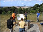 foster1.JPG |
Welcome to Foster Lookout. From here, on a clear day, you can see the South Gippsland hills, Corner Inlet and Wilsons Promontory. Foster Lookout is a great place to stop because you can get an overview of the geology and geomorphology of South Gippsland and Wilsons Promontory. The Warragul 1:250,000 geology sheet (pictured below) is extremely handy at this stop. Foster Lookout sits on the eastern side of the Strzelecki Ranges (in the Gelliondale Block), an uplifted package of Early Cretaceous volcanoclastic sediments of the Strzelecki Group. The Alberton Depression (lowland or graben) in front of us includes Corner Inlet, a large estuary, and the Yanakie Isthmus, a sandy bar connecting South Gippsland to Wilsons Promontory. Foster Lookout is separated from the Alberton Depression by the Gelliondale Monocline and the Waratah Fault. The Depression is filled with sediments from the Cenozoic Era (between 65 and 0 million years old) derived from weathering and erosional stripping of the surrounding South Gippsland rocks, mostly Cretaceous Strzelecki Group and Tertiary rocks including the Latrobe Group. Click here to download the entire Warragul 1:250,000 geological map from Geoscience Australia (6.1 Mb jpeg). |
 foster2.JPG |
Foster is the centre of the universe! |
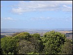 foster3.JPG |
In this view we're looking eastwards across South Gippsland and the northern part of Corner Inlet towards Port Franklin, Port Welshpool and Snake Island. You can see the low-lying lands of the Alberton Depression graben, filled with relatively recent sandy sediments. |
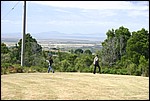 foster4.JPG |
This view looks more or less south towards Wilsons Promontory. Corner Inlet is clearly visible in the mid-ground but Yanakie Isthmus is hidden behind the trees to the right. Hills and mountains visible on Wilsons Promontory include (from left to right) Mt Singapore, Mt Roundback and Mt Vereker. |
 geology.jpg |
This is an extract from the Warragul 1:250,000 geological sheet. The immediate area of Foster Lookout (slightly to the west of "Foster"), the southeastern Strzelecki Ranges, Corner Inlet and northern Wilsons Promontory are depicted. The important things to note on this extract are the prominent fault lines that divide up the landscape, the red-coloured Devonian granites on Wilsons Promontory, the purple Devonian sedimentary rocks, the deep green-coloured Cretaceous rocks, the yellow Tertiary sediments and the light green to yellow Quaternary sediments. |
 rad.jpg |
This is an extract of a gamma-ray spectrometric image from the Warragul Geoscientific Data CD by the Victorian Department of Natural Resources and Environment. It covers roughly the same area as the geological map above. What is this image showing us? A gamma-ray spectrometric image depicts the naturally-occurring radioactivity in the top 30-50 cm of the Earth's surface by mapping gamma radiation from the decay of the radioelements potassium (K), thorium (Th, actually, its daughter product 208thalium) and uranium (U, actually, its daughter product 214bismuth) as red, green and blue, respectively. Bright colours indicate a relatively high amount of one or more of the radioelements and dark colours indicate little or none of the radioelements. Combinations of two or more radioelements results in different colours (i.e., yellow = red + green, or relatively large amounts of K and Th in the regolith) Compare this image to the geological map above, what does it tell us? Of course, all of these interpretations are based on knowledge from other areas. You really need to go and look for yourself to verify the interpretations. |
You can learn more about Foster Lookout and interpreting radiometric images for regolith by reading: W.D. Birch ed. 2003. Geology of Victoria. Geological society of Australia Special publication No. 23. 842 p. |
|