Waratah Bay - Walkerville North
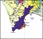 waratah_geol.jpg |
This image shows the geology of Waratah Bay, taken from the Warragul 1:250,000 geological sheet (Geological Survey of Victoria). The map shows Cambrian (Cv), Ordovician (Old) and Devonian (Dlc, Dll) rocks as fault slices making up Bell Point at Walkerville. The rocks are juxtaposed against each other by fault splays of the Waratah Fault, which is mapped further northeast of Walkerville but actually extends under cover and under water through to Cape Liptrap. Other deposits in the immediate vicinity of Walkerville mentioned on the geology map are Qpd - aeolian dune sands. Click here to download the entire Warragul 1:250,000 geological map from Geoscience Australia (6.1 Mb jpeg). The following images show some of the regolith-landform features of the beach cliffs and headland at Walkerville North. |
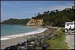 wb1.jpg |
This image is looking south towards Walkerville South from Walkerville North, with Bell Point visible in the background. Notice the thin, gently sloping beach composed of white quartz sand and a regolith profile in the cliff consisting of a lower unit of grey-coloured rocks and an upper unit of light-brown-coloured materials. Rocks in the foreground are basalt boulders dumped to prevent erosion along the road (they're not from here!). The beach slopes towards a well-developed shore platform which lies less than 1 m under the high tide mark. |
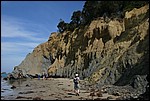 wb3.jpg |
Seen closer up, the regolith profile in the small headland between Walkerville and Walkerville South starts to resolve into different units. The lower grey-coloured material is a sequence of Early Devonian gray shales and sandstones of the Liptrap Formation. Bedding showing tight to isoclinal folding and some chevron folding becomes gradually more disrupted as you walk towards the headland, whereupon the rocks are replaced by a highly distorted limestone. The upper unit consists of a thick sequence of poorly sorted, light brown- and red-coloured clays and sands, with buff- to white-coloured clean sands of less than about 0.5 m thickness at the top of the profile underneath the vegetation. Do you notice the flat surface separating the lower gray and the upper buff-coloured regolith units in the profile? |
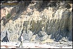 wb4.jpg |
Seen closer up, the gray lower regolith unit (folded Early Devonian turbidite) and the light brown-red upper unit (Quaternary sediments and aeolian sands) are separated by an almost horizontal line. Notice the rounded quartz pebbles and cobbles sitting along the interface in the top right of the image (look closely). This planar feature is interpreted to be an ancient shore platform that has been uplifted by modern (neotectonic) movement along the Waratah Fault and is now preserved by later sediments including water-worn quartz pebbles at the base of the sediments. |
 wb6.jpg |
This image shows the Waratah Fault Zone close-up. The outcrop at the far left is composed of highly disorganized limestone. The materials on the left are highly sheared and disrupted Devonian turbidites. Overlying soft regolith from fluvial and aeolian deposits has slumped and is draped over the lower Devonian units. |
 wb7.jpg |
The Waratah Fault, drawn on the map as a single discrete line, is a fault zone. What's the difference? A fault is a single, discrete plane of dislocation, whereas a fault zone is composed of a multitude of small fault planes. The materials shown here comprise a melange, or fault breccia. Large hard particles, here sandstone, sit in a matrix of sheared, smeared shale and smaller quartz particles. The large lumps have a rounded-over appearance gained by having their corners smoothed off by rotation as movement occurred along the zone. Finding materials like this lying around indicates the nearby presence of a fault zone. |
 wb8.jpg |
This pebble is composed of crinoidal limestone. Crinoids, or sea-lillies, grew in limey muds in deeper water around coral reefs in the Silurian and Devonian, and their ancestors still survive today. The round or ellipsoidal white shapes in the rock are cross-sections through crinoid stems. Look closely at the upper right hand side of the pebble and you'll see that some of the crinoid stems are offset. They have been cut through by a small fault. Here is direct evidence of faulting, on a small scale, next to the large scale Waratah Fault. |
You can learn more about the Waratah Fault at Walkerville by reading: W.D. Birch ed. 2003. Geology of Victoria. Geological society of Australia special publication No. 23. 842 p. R. A. Cayley, D. H. Taylor, A. H. M. VandenBerg and D. H. Moore 2002. Proterozoic - Early Palaeozoic rocks and the Tyennan Orogeny in central Victoria: the Selwyn Block and its tectonic implications. Australian Journal of Earth Sciences 49 (2), 225254. |
|